Sunday, 18 May, 2025

By A Staff Reporter
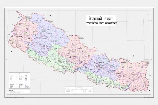
Kathmandu, May 25: The Ministry of Land Management, Cooperatives and Poverty Alleviation Sunday sent a circular to all local bodies and the government offices to bring the newly issued updated map of the country in use.
Joint secretary and spokesperson at the Ministry Janakraj Joshi said that the Ministry on Sunday circulated a notice to all local bodies and the government offices requesting them to bring the map into use and hang it in their offices.
According to him, the Office of the Council of Ministers had sent the notice to all seven states and 753 local bodies through the Ministry of Federal Affairs and General Administration.
Also, the Land Management Ministry in the letter has urged the government offices to print the official map of the country from its website and bring it into use in their respective offices, Joshi said.
Joshi said that the Ministry had published the official political and administrative map of the country in the Nepal Gazette on Friday (May 22).
The Ministry of Land Management had unveiled the map by organising a press meet on May 20 after the Cabinet meeting held on May 18 decided to publish the revised map of the country incorporating Limpiyadhura, Kalapani and Lipulek as its territory.

Do not make expressions casting dout on election: EC
14 Apr, 2022
CM Bhatta says may New Year 2079 BS inspire positive thinking
14 Apr, 2022
Three new cases, 44 recoveries in 24 hours
14 Apr, 2022
689 climbers of 84 teams so far acquire permits for climbing various peaks this spring season
14 Apr, 2022
How the rising cost of living crisis is impacting Nepal
14 Apr, 2022
US military confirms an interstellar meteor collided with Earth
14 Apr, 2022
Valneva Covid vaccine approved for use in UK
14 Apr, 2022
Chair Prachanda highlights need of unity among Maoist, Communist forces
14 Apr, 2022
Ranbir Kapoor and Alia Bhatt: Bollywood toasts star couple on wedding
14 Apr, 2022
President Bhandari confers decorations (Photo Feature)
14 Apr, 2022