Tuesday, 7 May, 2024

By Laxman Kafle
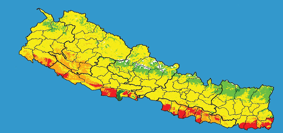
Kathmandu, Feb. 24: Nepal has developed a digital soil map for the first time aiming to support soil fertility management in the country.
Digital soil map (DSM) is a map created using computer technology to show various elements or properties of the soil. Such a map, based on the results of soil analysed in the laboratory through mathematical and statistical models, provides various information about the elements in the soil and its effects on the environment.
The National Soil Science Research Centre under the National Agricultural Research Council (NARC) developed the electronic map of soil quality with financial support of the International Maize and Wheat Improvement
Centre (CIMMYT) after four years of study.
“We have prepared the digital maps showing the soil conditions of different places. This digital map is an interactive map. This map has been prepared based on the analysis of the results of a total of 23,273 soil samples from 56 different districts, representing all the provinces of Nepal,” said Dr. Shree Prasad Vista, senior soil scientist of the National Soil Science Research Centre, NARC.
While preparing this map, 168 various environmental factors (covariates) that play a role in determining the properties of the soil based on satellite images have been considered, he said.
Then, on the basis of all these, predictions of soil properties of different places were made using a 'machine learning system' called 'Random Forest', he added.
Digital soil mapping has been widely used to develop statistical models of the relationships between environmental variables and soil attributes. From this map the users will be able to know the type of soil, acidity in the soil, the amount of organic matter, amount of nitrogen, phosphorus and potash and the amount of micronutrients, zinc and boron, said Dr. Vista.
Earlier on Feb. 14, a report on the electric mapping system was presented to the Prime Minister.
Digital soil mapping gives farmers and natural resource managers easy access to location-specific information on soil properties and nutrients, so they can make efficient and localised management decisions.
“Not only farmers, but also policy makers, researchers and technicians would be directly benefited from this map as policy makers can introduce specific policy based on the quality of soil for specific places and technicians too can use effective technology,” he said.
He said that Nepal is the first country to introduce nationwide digital soil map in South Asia.
“We have to update the web portal to make it more user-friendly and interactive. The map would be updated by collecting soil samples in different times as the productivity and quality of soil would change based on the crop plantation, use of fertilisers and other factors,” he said.
A separate web portal --- https://soil.narc.gov.np -- has been created to view this digital map.
Spokesperson of the Ministry of Agriculture and Livestock Development Dr. Shree Ram Ghimire said that soil properties have a significant influence on crop growth and yield response to management inputs.
“For farmers, having access to soil information can make a big difference in the adoption of integrated soil fertility management,” he said.

Do not make expressions casting dout on election: EC
14 Apr, 2022
CM Bhatta says may New Year 2079 BS inspire positive thinking
14 Apr, 2022
Three new cases, 44 recoveries in 24 hours
14 Apr, 2022
689 climbers of 84 teams so far acquire permits for climbing various peaks this spring season
14 Apr, 2022
How the rising cost of living crisis is impacting Nepal
14 Apr, 2022
US military confirms an interstellar meteor collided with Earth
14 Apr, 2022
Valneva Covid vaccine approved for use in UK
14 Apr, 2022
Chair Prachanda highlights need of unity among Maoist, Communist forces
14 Apr, 2022
Ranbir Kapoor and Alia Bhatt: Bollywood toasts star couple on wedding
14 Apr, 2022
President Bhandari confers decorations (Photo Feature)
14 Apr, 2022


.JPG)