Saturday, 27 July, 2024

Dr. Jagat K. Bhusal
The current territorial issue between Nepal and India involving some 400 sq. km sovereign land of Nepal on the north-west border in fact dates back to the period of Sugauli Treaty in 1816. This issue was also at its peak when a joint statement between India and China in 2015 named Lipulek pass as one of the routes for cross-border trade and pilgrimage between those two countries. And the Indian government has time and again admitted that the upper reaches of Kali are disputed.
The Sugauli Treaty ceded the district of Kumaon and Garhwal to the British which connected the British to the borders of Tibet for the first time from the west of Nepal and to the east through the treaty of Titalia 1817 with Sikkim. Article 5 of the treaty states: “The Rajah of Nepal renounces for himself, his heirs and successors, all claim to or connexon with the countries lying to the west of the river Kali and engages never to have any connexon with those countries or the inhabitants thereof.” This border river “Kali” is now called Mahakali in Nepal and Sarada in India.
The map of 2nd January 1816 is also the pictorial interpretation of the secret letter of 1st June, 1815 by Lord Hastings, the then Governor General, which states: “The eastern boundary will be the Kali, which rises in the Snowy Mountains, and pursues nearly a direct southerly course to the plains, where it assumes the name of the Gogra.” Mapping technology at that era was not as advanced as of today so the demarcation of the source of the uppermost reach of the river in the map (Map 1) is shown inside the cloud of snow and glaciers.
The map of 1819 (Map 2) had clearly demarcated the headstream course of “Kali R” as defined by Sugauli Treaty. This was done from surveys and information from the locals. This map and other maps then followed the main river principle as well. Supporting document to the map is letter of John Adams. After the Sugauli Treaty, Bhootiya Zamindar of Kumaon wanted to retain three villages namely, Gunji, Nabi and Kuti within Kumaon in the British territory. But, Bom Shah, Chautariya from Nepal, had sent an objection letter to the British regime claiming that those villages belonged to Nepal. In response to the claim of Bom Shah, John Adams, the acting secretary, who also served as acting Governor General (Jan-Aug 1823) had confirmed that those three villages lying eastwards of Kali River belonged to Nepal, so on 4 February 1817, he sent an order letter to GW Trail, Commissioner of Kumaon to surrender those villages to the regime of Nepal with a copy of the letter to Edward Gardner, the resident commissioner of British India in Kathmandu.
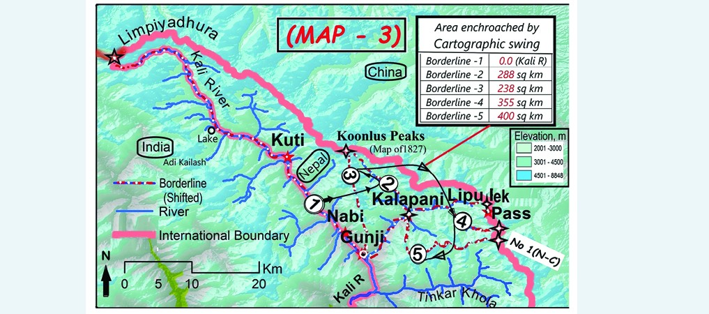
In the map of 1827, the borderline is presumably marked by an unnamed stream (Kalapani ?) shown to be originating from Koonlus range (Map 3, borderline 2) and meets the stream coming from Lipulek side in the east and then flows straight to the south till Gunji confluence. This stream is shown flowing almost straight north-south in the old map. This map has encroached about 238 sq km of Kali’s upstream and about 50 sq km of Lipu’s watershed.
The British India seemed to be attracted to the Kuti area because Kuti village (at about 3800 meters) had its value as it was the uppermost settlement serving as a base camp for those wanting to cross to Tibet, routes to Chhota Kailash and Parbati Kunda.
The Lipu basin, except for the seasonal and limited uses by pilgrims, is non-arable and non-settleable land.
Encouraged from encircling over Kuti area, the British India became more aware of Lipulek pass which, even in harsh and snowfall months, is crossable to Tibet for trade and transit, importantly as pilgrims’ route to Mt. Kailash and Mansarovar.
The British rulers, being aware of the report of Henry Strachey, a British surveyor during 1846-50, probably had had their interest in taking control of the Lipu pass. But, by 1857 there was an uprising against the British rule in Calcutta, Lucknow and other places in India (Thapa, 2013 and KC, 2004 in Ratan, 2015). And, by 1860s the British had also started friendly relations with Nepal. After the support of Gurkhas led by Junga Bahadur Rana to suppress the Lucknow uprising, the British had moulded not only a policy of friendship with Nepal but also had paid respect with the return of “Naya Muluk” in 1860, the plain land lost in 1816.
However, the British conspiracy began to encroach Lipulek pass by means of cartographic manipulation partly because of less technical knowledge on Nepal’s side and largely due to less frequent visits to that area due to remoteness. Lipulek pass did not hold much attraction to Nepali rulers because of Hilsa and Tinker pass being easier routes compared to the former.
The border agreement of 1845 adopted the fixed border principle and after the Naya Muluk Treaty of 1860, the borderline in the southern plain is marked by “Jange Pillar” with auxiliary reference pillars.
As the river course in the mountains hardly changes, the western border of Nepal in the mountain part remains without border pillars till today. Several other maps published in 1827, 1835, 1846, 1850, 1856 had also confirmed that the river originating from Limpiyadhura is Kali.
Limpiyadhura as the origin of Kali is also proved by the river science perspective postulated by John Playfair (1802), R E Horton (1945) and AN Strahler (1964). The main river at any confluence is distinguished from its length, its water volume, its watershed area and number of tributaries to it (Bhusal, 1996). The average water flows, the river length and the watershed area of Kali (Kuthi Yanti) are about three times larger, 2.5 times longer, and three times greater than Lipu (or Kalapani) stream respectively at the Gunji confluence.
After 1865-77, the Kali River at its uppermost reach (Gunji to Limpiyadhura) was named as KuthiYanti, another cartographic manipulation. Later, around the 1880s, the British India realized that a small stream cannot be the main river, so there was yet another manipulation.
A map of Tibet-Nepal-United Provinces published by the surveyor-general of India in 1881showed three different shedding - one type for India including Kuti, another for Nepal including Lipu and another type of shedding for Tibet. It intended to mark the Kali as the border up to Gunji confluence and north from Gunji, the watershed divide line as the borderline (Map 3, borderline 3).
The Gazette of Amora in 1911 had attempted to justify the map manipulation by stating, “The Kali on the east has its true source in the Kuthi Yanti which after the fall in the Kalapani river takes the name of Kali”.
The map of The United Provinces (1907-09) is also coloured accordingly which encroaches about 238 sq km and leaves the whole watershed of Lipu (Kalapani) towards Nepal.
After India got independence, both the countries made a peace treaty in 1950, which recognizes the Sugauli Treaty by stating, “The two governments agree mutually to acknowledge and respect the complete sovereignty, territorial integrity and independence of each other.” This factually recognizes the territorial integrity of two countries set by the Sugauli Treaty.
The local people had noticed a few tent camps of Indians on the left bank of Lipu at Kalapani at around 1952. Till 1961, India’s motive seemed to hold Lipulek pass totally within Indian territory.
The Nepal-China border agreement treaty 1961 has marked No. 1 pillar at the junction of Lipu, Tinker and Karnali watersheds, which gave inspiration to India to push cartographically Nepal’s border a few kilometers eastward from Lipulek (Map 3, borderline 4, fourth manipulation) by also considering the Lipu stream course as borderline as per river science, whereas tri-country border point actually lies at Limpiyadhura, 53 km west of Lipulek. Strategically, India attempted to take out Lipulek and almost 70 per cent area of Lipu watershed from Nepal after the defeat in war with China in 1962 (Map 3, borderline 5, fifth manipulation).
The map published by India in November 2019 has again marked the Kali River as border up to the artificial source and therefrom, following watershed divide lines to the south up to the point where Tinker, Lipu and Karnali watershed meet (Map 3, borderline 5). The motive underlying the joint statement made by the Chinese president and Indian prime minister in 2015 is also to encroach the Lepulek pass permanently by keeping Chinese witness to the process. Nathu La (about 4200 m) in Sikkim lies about 800 km to the east of Lipu pass and Shipki La (about 3200 m) lies at 280 km to the west of Lipu pass (about 5100 m). This has been motivating in shifting Kali border point upto Kalapani and watershed divide line therefrom encroaching about 400 sq km of land.
Since 1962, India had been extending its army camp and bunkers on both banks of Kalapani (or Lipu) stream despite continuous objection from Nepal. Bhairab Risal, a 93 years old legend of Nepal, is a living proof of the census of Kuti, Nabi and Gunji in 1961. Land tax records of Kuti available in Doti district of Nepal also prove that area upto Limpiya dhura belongs to Nepal.
Similarly, Bahadursing Yetwal (1960), Premsing Dhami (1990), Madan Bhandari (1993) made Limpiyadhura-Lipu encroachment by India a national issue. The joint report (1973) by Puruswotam Regmi (Home Ministry) and Hari Prasad Khatri (Ministry of Foreign Affairs), Dwarika Dhungel (1981), letters to UN on behalf of Nepali people including Hiranya Lal Shrestha (1998) and many others have been continuously opposing Indian encroachments.
Finally, can it be assumed that India would be blocked completely to China in the future without Lipulek pass? Is India still feeling unsafe from China so that it needs the Indian army at the bunker on the land encroached from Nepal? Is not India familiar with war technology that has been moving further from GPS guided missile? And further, does not India want to be friendly with its neighbours in behavior, not in crocodile tears and not on the givers-beggars principle?
India must find answers to such questions by herself to be a nation that keeps pace with changing times and is globally friendly. India should also realize the pain of Nepal, suffering from being landlocked and frequent transit blockades which have been resulting in economic and humanitarian crisis due to which it was forced to establish trade and transit protocol with China.
India must think positively about the signing of trade and transit protocol between Nepal and China and on how to make the best use of such a relation for its benefits as well.
Nepalis have been feeling bitter about the enforcement of water resources treaties. Therefore, if India respects moral values, if it intends to be a rising power and a nation in contest with China, Japan and US in technology and economy and, more importantly, wants to be a good neighbour, it is the right time for India to withdraw its army camp from the Nepali territory, east of Limpiyadhura to Kalapani-Lipulek and respect the Nepali sentiments. Unless the sovereign parliaments of both nations approve the border treaty, unilateral cartographic manipulations alone cannot overwrite the border by Kali river unto Limpiyadhura set by the Sugauli Treaty.
Furthermore, if Nepal keeps some of her territorial areas outside the official map, India gets excuses to keep encroaching for years to come. So, Nepal must withdraw her defective map and release the correct map with a white paper note. In addition, Nepal has to show its vivid appearances over that region with development activities focusing on local livelihoods, high altitude tourism facilities with access road and electricity, and keep continuous moral pressure over India to retreat from the encroached areas, not only over Limpiyadhura-Lipu but also Susta and other locations.
A professional hydrologist and ex-chairman of ETFC, the author can be reached at bhusaljagat@yahoo.com

Do not make expressions casting dout on election: EC
14 Apr, 2022
CM Bhatta says may New Year 2079 BS inspire positive thinking
14 Apr, 2022
Three new cases, 44 recoveries in 24 hours
14 Apr, 2022
689 climbers of 84 teams so far acquire permits for climbing various peaks this spring season
14 Apr, 2022
How the rising cost of living crisis is impacting Nepal
14 Apr, 2022
US military confirms an interstellar meteor collided with Earth
14 Apr, 2022
Valneva Covid vaccine approved for use in UK
14 Apr, 2022
Chair Prachanda highlights need of unity among Maoist, Communist forces
14 Apr, 2022
Ranbir Kapoor and Alia Bhatt: Bollywood toasts star couple on wedding
14 Apr, 2022
President Bhandari confers decorations (Photo Feature)
14 Apr, 2022